Activity of department No. 2 in 2017-18
Activity of department №2 in previous years
Glaciological research
Monitoring changes and field studies on the Abramov, Golubin, Suek, glaciers of the Atbashi Range and glaciers in the basin of the Bartang River in Tajikistan
In 2017-18, in the framework of the project “Study of representative glaciers of Kyrgyzstan”, research of glaciers Abramov, Golubin, Enylchek, Western Suek, No. 354, No. 599 and No. 178 is ongoing, using interpreting Landsat 8 and other satellite images and field measurements of ablation and mass balance. Within the IKI EbA project (Ecosystem Adaptation to Climate Change in the Highlands of Central Asia), similar work is underway in the basin of the Bash-Kaindy River on the northern slope of the Atbashi Ridge, where ablation rods are set on the glacier No. 182; the boundaries of the glacier tongue are defined. As for glaciers of Tajikistan, an analysis of their changes based on the interpretation of space images was performed.
The interim results within the IKI EbA project are published on: http://www.caiag.kg/ru/struktura-otdely/otdel-2/publikatsii-2-go-otdela/ (Usubaliev R., Mandychev A., Osmonov A., Kalashnikova O., Shabunin A., Azisov E., Esenaman M., Podrezova Yu. Report on the results of works for 2016-17 under the EBA project "Adaptation to climate change based on the ecosystem approach in the highlands of Central Asia". (CAIAG), 2018. 52 p.).
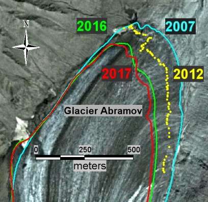
Boundaries of the Abramov Glacier’s tongue in 2007-2017 from Geo Eye 1 space images from 19/07/2007, on-ground GPS measurements in 2012 and from the Landsat 8 images in 2016 -17.
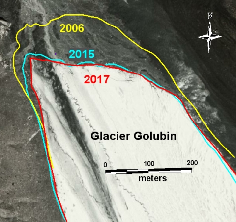
Boundaries of the Golubin Glacier’s tongue in 2006-2017 from Quick Bird space images from 24/07/2006. Landsat 8 images from 2015 and WorldView 2 images from 13/08/2017.
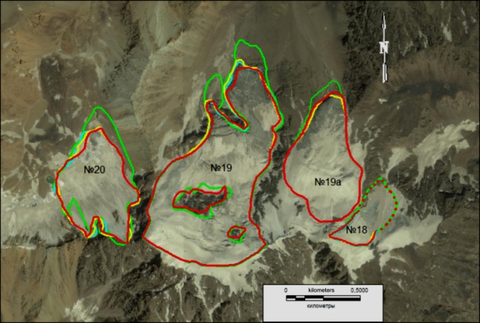
The boundaries of the glaciers 18.19, 19a, 20 in 1968 (green), 2002 (yellow), 2011 (blue), 2016 (red) against the backdrop of the Ikonos space image from 24.07.2011.
In 2017-18, the research continued under the Global Observatory of Central Asia program on the Enilchek glacier, at the Merzbacher high-altitude scientific station. In summer, new ablation rods were set and ablation measurements were taken on the Southern Enilchek Glacier. In addition, the glacier’s surface velocity was measured by rods displacement during the year.
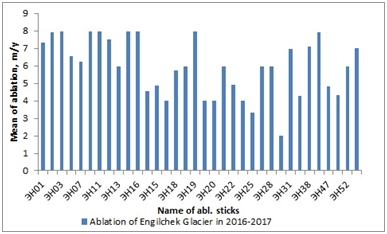
The ablation value on the Southern Enylchek Glacier for 2016-17.
In 2018, work on interpreting glaciers on the northern slope of the Teskey Ala-Too Ridge using the "Landsat TM" (1990) and
"Landsat 8" (2017) satellite images, was completed. In the interim from 1990 to 2017, 580 glaciers were interpreted with a total area of 430.8 km2. All glaciers have a general degradation trend with an average area decrease of 6.4%.
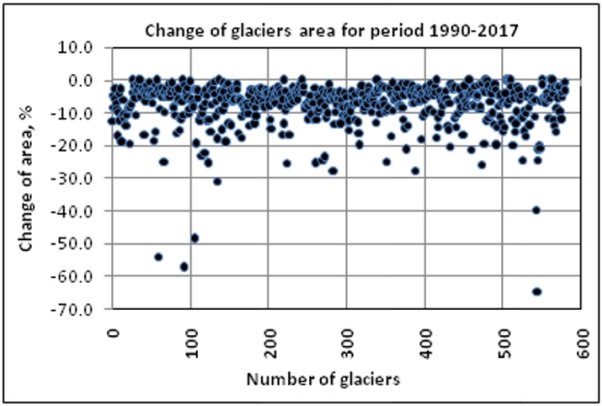
Number versus changes of glaciers on the northern slope of the Teskey Ala-Too Ridge in 1990-2017
Catalogue of Glaciers of Kyrgyzstan
In the framework of case studies in 2018, the Catalog of Glaciers of Kyrgyzstan was published: http://www.caiag.kg/ru/struktura-otdely/otdel-2/publikatsii-2-go-otdela/ (Shabunin A. Catalog of Glaciers of Kyrgyzstan (CAIAG), Bishkek, 2018). In this catalog, the state of glaciation as of 2013-16 and its change since the preparation of the Catalogue of Glaciers of the USSR (CGUSSR) in the 70s of the 20th century is shown based on the interpretation of the Landsat 8 satellite images and on comparison with the CGUSSR.
In total, according to the Landsat 8 images as of 2013-2016, there are 9 959 glaciers in the territory of the Kyrgyz Republic with a total area of 6 683.9 km2, including 6 227 glaciers greater than 0.1 km2 with a total area of 6,494.0 km2, and 3,732 glaciers smaller than 0.1 km2, with a total area of 189.9 km2.
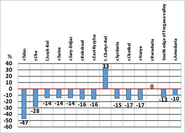
Change in the glaciers area (%) in the main river basins of the Kyrgyz Republic from 40-70s of the twentieth century to present
Hydrological Study
In 2017-28, the types of feeding and cyclicity of the maximum runoff on the rivers of the Issyk-Kul basin were studied.
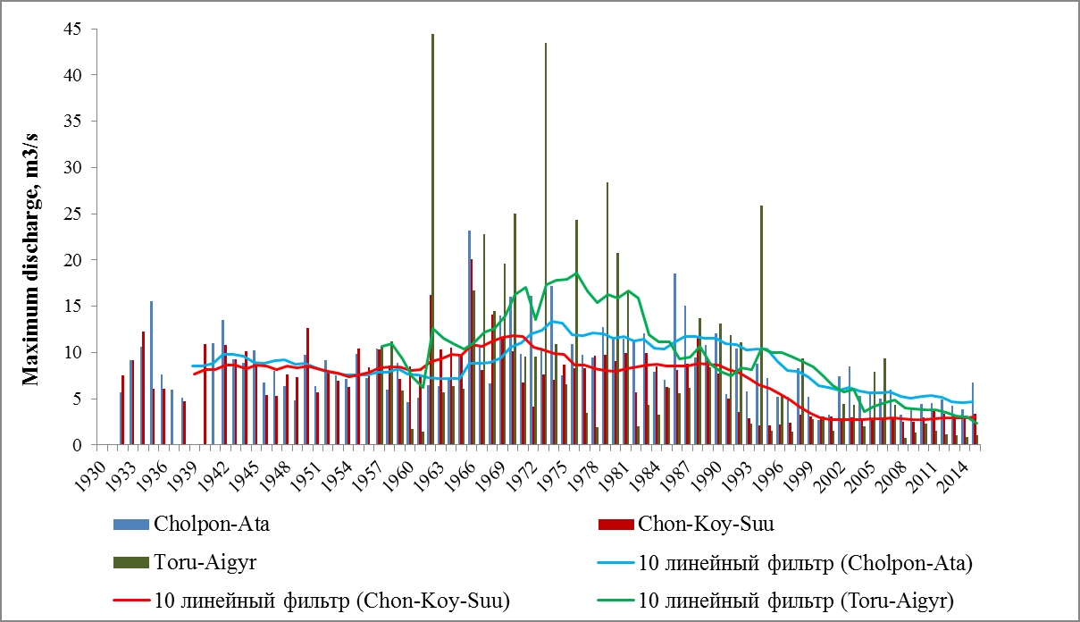
The maximum water discharge on the rivers of the southern slope of the Kungey Ala-Too Ridge.
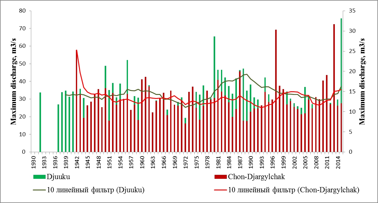
Maximum water discharge in the rivers of the northern slope of the Teskey Ala-Too Ridge.
Hydrological modeling was also compiled in the framework of the CAWa project (Long-term forecast of Central Asian rivers runoff based on snow cover data from MODIS images); work on the project GlaSCA-V (Dynamics of runoff in the upper reaches of the Chu River in the past and the future. Evaluation of the of rain, thawed snow and glacial runoff contribution to the overall runoff of the upper reaches of the Chu River) is ongoing.
The methods proposed for forecasting seasonal runoff in the summer months have correlation coefficients (R) of 0.50-0.92, and the accuracy of the forecasts for the period 2000-2017 is 77-100%.
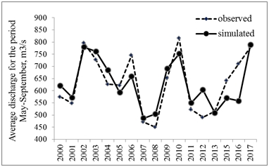
Forecast of Naryn river runoff at the hydropost Uch-Terek
Monitoring the Level of the Issyk-Kul Lake
Observation of the topography of the Issyk-Kul Lake level along the tracks of the CRYOSAT 2 altimetry satellite is ongoing in different years and seasons of the year. The results indicate a lake level decrease in the central part. This phenomenon, in our opinion, due to its permanence and independence from seasonal changes in hydrological conditions, is caused by gravitational attraction of two sublatitudinal ridges - the Teskey and Kungei. To a lesser degree, the deflection of the lake level may be due to the anticyclonic circulation of the lake water, as well as the temperature and salt variations in the water density.
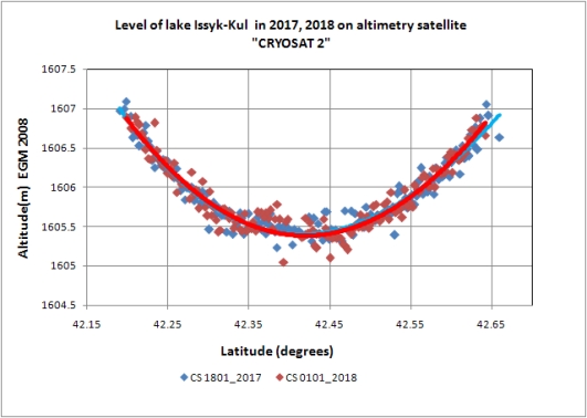
The lake level of Issyk-Kul from "CRYOSAT 2" satellite data along the sub-meridional profiles
Monitoring Oil Pollution Movement in the Town of Balykchy
In 2017, samples of groundwater in the coastal part of Lake Issyk-Kul and directly from the lake were taken in the area of groundwater contamination with oil products in the town of Balykchy, in the area of the operating oil depot. One sample (No. 257) of lake water and two samples (No. 258,259) of groundwater were taken. Groundwater samples were taken from a one-meter hole. Analyzes were performed by a Fluorat-02-3M fluid analyzer in the laboratory of the Environmental Monitoring Department of the State Agency for Environmental Protection and Forestry under the Government of the Kyrgyz Republic. Petroleum products were found in the water samples, but their concentration of 0.05-0.06 mg/l meets the MPC (maximum permissible concentration).
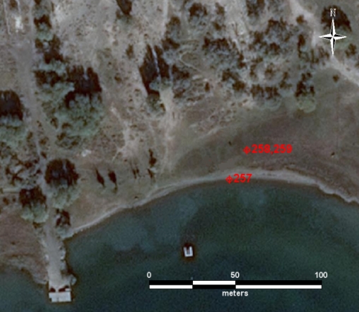
Location of water sampling points from the lake and groundwater
Monitoring Groundwater Level
In 2018, monitoring of groundwater level and temperature continued with OTT_ecoLog_500 sensor installed in well No. 1301-4, which belongs to the observation network of regime wells of the Kyrgyz Complex Hydrogeological Expedition of the Ministry of Natural Resources of the KR (KCHE). The measured parameters (temperature and depth) are stored every hour and transmitted via the cellular GSM network to CAIAG server. One can obtain this data and see the graph of the groundwater level change at: (http://gdbweb.caiag.kg/WATER/index.php). Well No. 1301-4, located in Kyrgyzstan on the western outskirts of Bishkek (42 ° 52'1.06 "C 74 ° 28'50.31" B, the absolute elevation is 739 m). View Well No. 1301-4 on a larger map.
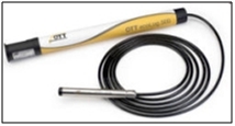
Sensor «OTT_ecoLog_500»
In 2018, Ott Orpheus Mini water level sensor was installed in well №1089 of the KCHE which is located like №1301-4 well, in Bishkek, within the Alaarcha groundwater deposit. The depth of the well is 59 m, land elevation is 778 m.
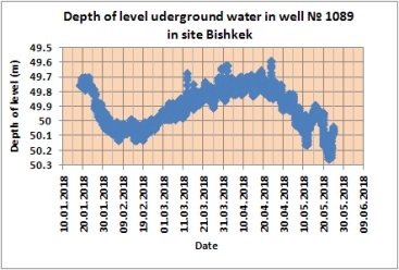
Change in groundwater level from January to May 2018 in the well No. 1089
Measurement of Meteorological and Hydrological Parameters
During the project EbA (Adaptation based on ecosystems to climate change in the highlands of Central Asia) in 2017, in Kyrgyzstan (village Bash-Kaindy) and Tajikistan (village Hijez), CAIAG researchers set automatic weather stations, which transmit the main meteorological parameters to CAIAG through the cellular network.
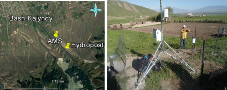
Automatic meteostation near the village Bash-Kaindy, Kyrgyzstan
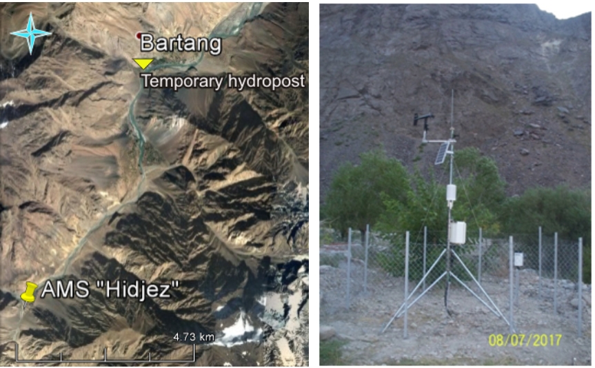
Automatic meteostation near the village Hijez, Tajikistan
In May 2018, an automatic gauging station was installed in the Bash-Kaindy River using Ott Mini Orpheus sensor, which measures the change in the level and temperature of the river water and stores data in the data logger.
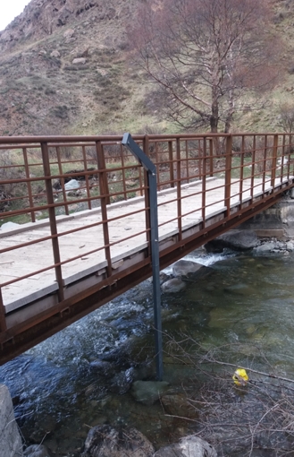
Ott Mini Orpheus sensor for measuring river water level and temperature, installed in the Bash-Kaindy River
Participation in Conferences
- General Assembly of the European Union of Geosciences, Vienna, Austria, 8-13 June 2018.
- International Symposium "Between Europe and the East. Central Asia and the Caucasus in the focus of science and higher education ". Almaty, Kazakhstan, April 16-18, 2018.
- International Conference "SnowHydro - 2018" (Geographical Institute), Heidelberg, Germany, February 12-15, 2018.
- RusDendro 2017, Report: "Potential for the use of wood from archaeological sites for the reconstruction of extreme events", Altai, Barnaul, September 5-10, 2017.
- TRACE 2017 Report: “Extreme paleoclimatic events for North-Western Siberia using archaeological wood from the Nadymskiy Gorodok archeological site”, Kaliningrad, Svetlogorsk, 16-21 May 2017.
