UNDP Disaster Risk Management Program


Program Name UNDP Disaster Risk Management Program
Short name: Create / update disaster risk database (landslides)
Place of work: Kyrgyzstan
Type of contract: Institutional contract
Method of procurement: Direct (Waiver)
Duration: 7 months from the date of signing the contract
The United Nations Development Program is a global development network of the United Nations that promotes positive changes in people's lives by providing countries with access to knowledge, experience and resources. The UNDP office in Kyrgyzstan is a reliable partner of the country in its efforts aimed at the development of the country and the achievement of a real improvement in the life of the population. The UNDP office in Kyrgyzstan coordinates the UN development activities in the country and assists in achieving the Millennium Development Goals, specific goals and objectives in priority areas, including poverty alleviation, health, education, the environment, human rights and partnerships that have been approved by world leaders at the Millennium Summit in 2000.
In 2005, the UN Global Summit, held in Kobe, Japan, adopted the Hyogo Framework Program of Action (HFA) for the years 2005-2015: “Improving the resilience of states and communities to disaster risk”.
This global agenda includes five priority areas, the achievement of which is relevant for the Kyrgyz Republic, on the one hand, and commitment, on the other hand, as countries participating in this global agenda. The Hyogo Program of Action is designated by the United Nations as part of the International Strategy for Disaster Reduction (ISDR), in which the United Nations Development Program (UNDP) is a key participant.
In order to implement the second HFA priority area (knowledge of risks and the implementation of necessary actions) within the framework of the UNDP Project “Effective Disaster Risk Management for Sustainable Development and Human Security” (the second result: a comprehensive disaster risk assessment system), it is planned to create a national hazard register for disaster risk. To this end, the UNDP Program assists the Department of Monitoring and Forecasting of the Ministry of Emergency Situations in the implementation of the research program on the study of hazardous natural processes and phenomena in terms of creating a database on landslides and landslide-prone sites.
Aim
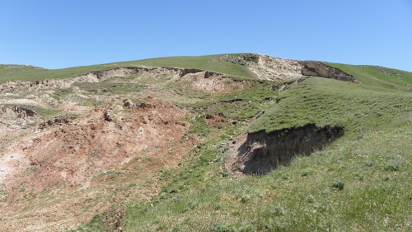
The main purpose of this Terms of Reference is to create a cadastral database of landslide sites in the Alai district of the Osh region of Kyrgyzstan.
AMOUNT OF WORK
As part of this Terms of Reference, the following types of work / tasks are provided:
- Collection of stock and archive materials on landslides and landslide sites (preparatory work)
- Field work on the survey of landslide-hazardous areas (field work)
- Processing field data and compiling a database (office work)
- Drawing up a report on the work performed
The amount and content of work:
- Preparatory work
- a) Collection of information on landslide sites, including the acquisition of satellite images;
- b) Processing of preliminary information (interpretation of satellite images, the selection of zones / regions of landslide distribution);
- c) Detailed method and work plan;
- d) Drawing up and coordinating the work schedule.
Field work
- a) Survey of landslide sites on the ground (description, systematization and inventory compilation according to Form 1);
- b) Determination of the possible impact of the landslide process on nearby farmland, housing, engineering structures and communications.
- c) Drawing on the overview map (scale 1: 100 000) of the landslide area based on the GPS survey;
- d) Mapping a landslide (landslide area) of 1: 5000 scale or another scale, depending on the situation with a description of the possible area of damage.
- Cameral work
Processing and summarizing fieldwork materials for the followings:
- a) Standardization of landslide areas (according to lithological composition);
- b) Compiling a database of landslide sites on the basis (basis) of a GIS program (advantage of ArcGIS or other compatible software products).
The database should contain the following information for each landslide site:
Site location (with reference / link / to the overview map),
Brief engineering and geological description of the site / landslide (according to Form 1),
Description of the zone of possible influence of a landslide / plot,
Photo of the site / landslide and zones of possible influence.
The report should contain the following sections:
- a) Introduction
- b) Research Methodology
- c) Description of the results of the work performed
- d) Conclusions and recommendations
- e) Applications (database table, overview map and sidebar maps, drawings, photographs, references, etc.)
- Requirements for the format and number of copies of the report:
Three paper color copies in binding and two electronic versions (Word and Pdf.) on CD,
Electronic data files (digital and informational layers / files) with full description and content of the database on landslides on CD.
Additions or changes to the above scope and content of works, or reflection of other aspects in this area known to the performers of this Terms of Reference will be agreed in working order in the process of developing and presenting results.