Activity of the department No. 2 in 2016


Activity of the department №2 in previous years
Glaciological research
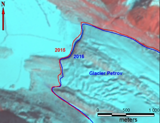
Monitoring of the changes and field studies on the glaciers of Abramov, Golubin, Suek, glaciers of the Atbashi Range and glaciers in the basin of the Bartang River of Tajikistan
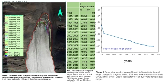
In 2016, research on the Project «Research of glaciers in Kyrgyzstan», glaciers of Abramov, Golubin, Enylchek, Western Suek, No. 354, No. 599, No. 178, continued, by deciphering the satellite images of the «Landsat 8» satellite and other satellites and field measurements of the ablation parameters and balance of mass. In the framework of the IKI EbA project (Ecosystem adaptation to climate change in the highlands of Central Asia), similar work was carried out in the Bash-Kaindy on the northern slope of the Atbashi range, where ablative slats were installed on glacier No. 182. with GPS fixed the boundary of the glacier's tongue and samples of melted glacial waters were selected, and on the glaciers of Tajikistan an analysis of their changes based on the interpretation of space images was performed.
Within the framework of the project "Capacity Building and Strengthening for Climate Observing Systems" (CATCOS), a summer school on measuring the mass balance and its analysis at the Western Suek glacier was conducted jointly with colleagues from Switzerland from 13 to 20 July 2016.
Changing of the tongue boundaries of glacier No. 354 (Ak-Shyirak), based on the results of interpretation of the "Landsat" satellite images from 1972 to 2016
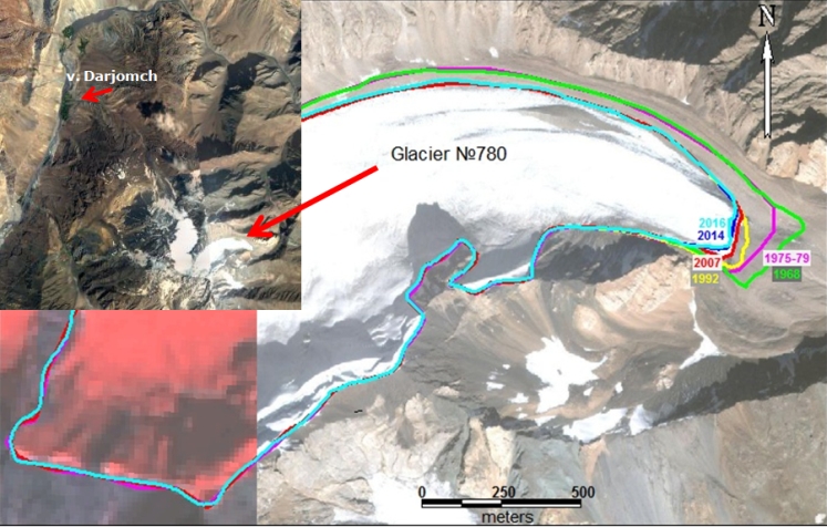
Study of changes in glaciers in Tajikistan, in the Bartang river basin, near the village of Darzhomch (Glacier No. 780, catalog of glaciers in the USSR). Based on the interpretation of space images of satellites "KH-4B" system "Corona" 1968, "Ikonos" 2007, "Landsat 8" 2016.
Study of glacier Enilchek
In 2016, studies continued within the Global Observatory of Central Asia program on the Enilchek glacier, at the Merzbacher high-altitude scientific station. During the summer period, new ablation slats were installed on the Southern Inylchek glacier and ablation measurements were made. In addition, the ice surface velocity was measured both by measuring the displacement of ablative rods during the year and by reflectors in the summer using an electronic total station. The determination of the speed of ice movement on the surface of the glacier on the radar images of the satellite "Sentinel 1" was also performed.
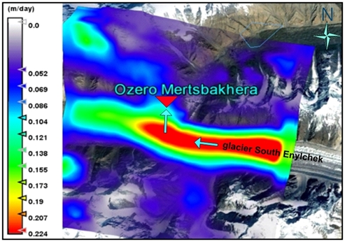
Speed movement of surface ice of glacier Southern Enilychek on radar image of the satellite«Sentinel 1»
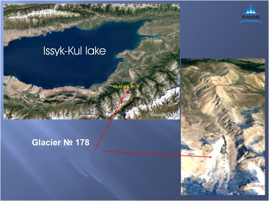
Study of glacier №178
In 2016, the first field work was carried out on Glacier No.178. With the help of an electronic tachymeter, a topographic survey of the transverse and longitudinal profile of the glacier and the boundaries of glacial lakes was carried out. Is the decoding of the satellite image "Landsat 8" from 2016 and comparison with topographic maps with the state of the terrain for 1943-1956? (Until 1974), 1980 and 2016.
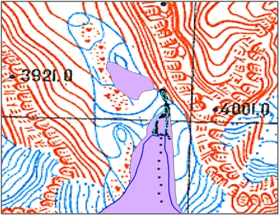
Glacier № 178 in 1943 (1956) - the main background, 1974 (1980) – purple; in 2016 - dark blue outline. Light blue – borders of lakes. Asterisks - points of topographic survey
Inventory of glaciers in Kyrgyzstan
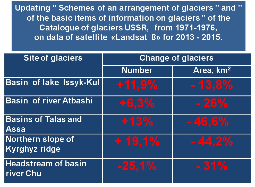
In 2016, work was carried out to account for the number and area of glaciers in Kyrgyzstan based on the data of the Glacier Catalog of the USSR and the interpretation of the satellite images of the "Landsat 8" satellite for the period 2013-2016. In 2016, this work was carried out in almost half of the territory of the Republic. Part of the results published: http://www.caiag.kg/ru/struktura-otdely/otdel-2/publikatsii-2-go-otdela
Hydrological studies
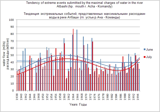
Changes in the water regime of the Issyk-Kul basin
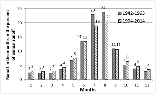
Investigations of the impact of climate change on the intra-annual flow regime of the Issyk-Kul basin were carried out using the example of glacial-snow rivers in the northern slope of Teskey Ala-Too. It is established that the increase in the duration of the warm period influences the redistribution of the water regime - in the summer months the share of the runoff for the period 1993-2013. Decreases by 3-4% in comparison with the period 1942-1992gg., And in spring and autumn - increases by 0.5-1% for the same periods.
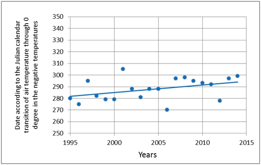
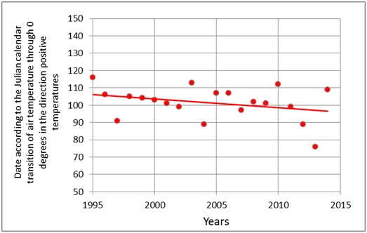
Illustration of the increase in the duration of the warm period in the Issyk-Kul basin, passage of air temperature through 0 ° C towards negative and positive temperatures
Hydrological modeling and forecast in the R-program.
One of the programs widely used in statistical analysis of various series of data (meteorological, hydrological) is the open source R-program. The developed methodology for forecasting river runoff for the vegetation period in this software provides good results and was proposed for the practice of operational hydrological forecasting. In March 2017, trainings were conducted in the department of hydrological forecasts of Kyrgyzhydromet and the methodology was submitted for testing and implementation for making forecasts in the operational mode. The methodology was developed on the inflows of water into the large reservoirs of Kyrgyzstan (Toktogul, Orto-Tokoy and Kirov).
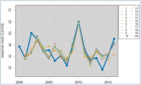
Variants of the results of modeling river flow for 20 models, calculated in the "R-program" for the flow of water into the Orto-Tokoy reservoir
Climatological studies
Climate change in the Ak-Shyirak massif area and its impact on glaciers
Analysis of climate change in the area of the Ak-Shyirak massif was made according to the data of the "Tien-Shan" weather station (WS) of Kyrgyzhydromet for the period from 1930 to 2015. Figure1 shows some elements of the analysis of annual air temperatures and precipitation, which indicate a stable tendency to air temperature increase and precipitation reduction in the observed area.
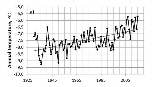
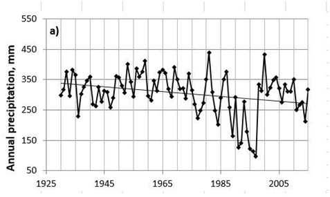
Fig.1.Annual temperature and precipitation coarse by the "Tien Shan" WS for the period of 1930-2015.
The general air temperature trend, starting from 1930 to 2015, shows a statistically significant increase at a rate of 0.2 ° C / 10 years. In the period 1930-1975, a slight increase in the average annual temperature by 0.5 ° C was noted, and the period of 1976-2015 was characterized by a more intensive increase, by 1.7 ° C. The most intensive growth was observed in winter and spring, while in summer and autumn the temperature rise was insignificant. At the same time, the change in annual amount of precipitation, according to a significant linear trend, is -7.88 mm for every 10 years, and in general, for 86 years the precipitation decreased by 68 mm or by 22% from the base rate. The decrease of annual precipitation was due to significant reduction of summer precipitation, at -85 mm or 52% of the base norm. Current estimates of changes in the glaciation of the Ak-Shyirak Massif show that until the mid-1970s, the degradation of glaciers was slow, and from the mid 1970s it became more intensive. The rates of glaciation parameters degradation, both in the general period and for two periods, correspond with the different values of the annual and seasonal temperatures increase in these periods against general decrease of annual, spring and summer precipitation.
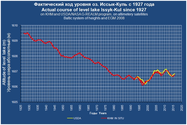
Observation of the change in the level of the Issyk-Kul lake according to altimetric satellites
In 2016, observations of the level of Lake Issyk-Kul continued according to the altimetric satellite "Jason3", comparing the results of lake level measurements at the posts of "Kyrgyzhydromet" and satellite measurements.
Monitoring of groundwater level
In 2016, monitoring of groundwater level and temperature was continued through the sensor "OTT_ecoLog_500" installed in well No. 1301-4, the observation network of regime wells of the Kyrgyz complex hydrogeological expedition of the Ministry of Natural Resources of the Kyrgyz Republic. The measured parameters (temperature and depth of the level) are stored at a frequency of 1 hour and transmitted via the cellular GSM network to the CAIAG server; you can obtain this data and see the schedule of the groundwater level change at: (http://gdbweb.caiag.kg/WATER /index.php). (http://gdbweb.caiag.kg/WATER/index.php).
Well No. 1301-4, located in Kyrgyzstan on the western outskirts of Bishkek (42 ° 52'1.06 "C 74 ° 28'50.31" B, the absolute mark of the earth's surface is 739 m).
Look at the Well № 1301-4on a larger map

Sensor "OTT_ecoLog_500"
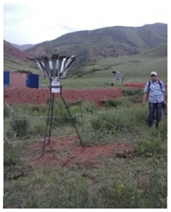
Measurement of atmospheric precipitation
In 2016 the measurement of atmospheric precipitation with the help of a total precipitation gauge continued at the site of the landslide "Tatyr", located 30 km south of Bishkek.
Look at Landslip Tatyr on the map
IKI EbA project
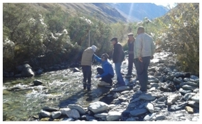
Within the framework of the IKI EbA project, an analysis of the hydrological regime of the At-Bashi river was carried out and hydrometric measurements were made on one of its tributaries - the Bash-Kaidy river. Based on the interpretation of space images, the nature of the channel processes of the At-bashi river in the area of the pilot section.
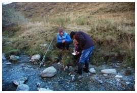
In 2016, in the village of Bash-Kaida in the Atbashinsky district, a total precipitation gauge was installed within the framework of the Iki EBA project and measurements of atmospheric precipitation were started.
Dendrochronological studies
The dendrometeorological station established in 2011 on the territory of Sary Chelek Biosphere Reserve has ceased to function since 2015. Since 2016 only dendrometer data are loaded from model trees, for each growing season.
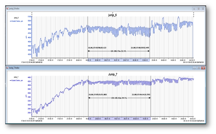
Data of dendrometers "ECOMATIK" from model trees for summer periodFrom the Sary-Chelek dendro station from June to August 2015
Participation in scientific conferences
Moldobekov, A. Mandychev, R. Usubaliev, A. Shabunin, A. Osmonov, E. Azizov, O. Kalashnikova, Yu. Podrezova, N. Shaidyldaeva "Water resources of Kyrgyzstan in the conditions of climate change". International scientific-practical conference "Water resources of Central Asia and their use". September 22-24, Almaty, 2016
Moldobekov B.D, Podrezova Yu.A., Mandychev A.N, Kalashnikova O.Yu., Pavlova I.A. "Research on the Trend of Climate Change in Kyrgyzstan". International Conference, International University of Kyrgyzstan, Bishkek, 2016.
Podrezova Yu.A., Pavlova.A.A. "Climate change in the area of the Ak-Shyrak massif and its impact on glaciers." XVI Glaciological Symposium "Past, Present and Future of Earth's Cryosphere". May 23-29, St. Petersburg, 2016.
Mandichev A.N, Usubaliev R.A, Azisov E.A. "Dynamics of changes in the area of the Abramov glacier according to remote sensing data, ground measurements and published data". 16th International Glaciological Symposium "The Past, Present and Future of the Earth's Cryosphere" in St. Petersburg (Russia) May 24-27, 2016.
Kalashnikova O.Yu., Gafurov A. "The use of terrestrial and satellite data on the snow cover for the forecast of river flow". 16th International Glaciological Symposium "The Past, Present and Future of the Earth's Cryosphere" in St. Petersburg (Russia) May 24-27, 2016
Kalashnikova O.Yu., Gafurov A. "GIS-in-Central-AsiaConference" (GISCA 2016): Green plantations. GIS-in-Central-AsiaConference (GISCA 2016). "Water availability in Naryn basin using MODISsnowcoverdata". Perspectives and Constructions "from April 28 to 30, 2016 at the Kyrgyz State University named after. Arabaeva KSUSTA, in Bishkek.
Kalashnikova O.Yu. "Use of MODSNOW to develop methods for long-term hydrological forecasting". International Seminar "Use of MODSNOW software for monitoring snow cover in mountainous areas Ts.A. With a view to hydrological forecasting "in Tashkent (Uzbekistan) from July 31 to August 7, 2016.
Konovalov V.G, Gafurov A., Kalashnikova O.Yu. "Correction of the model of formation of river flow by remote snow cover data". 14th All-Russian Open Conference "Modern problems of remote sensing of the Earth from space". 14-18 November. Moscow, 2016.